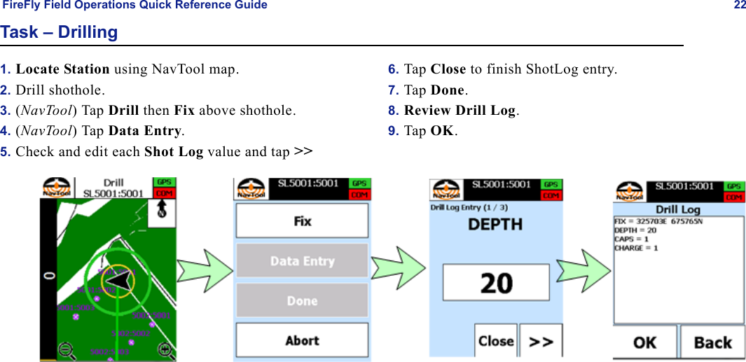
INOVA Geophysical Equipment FSU3 FSU-3 User Manual Field Operationsfcc

INOVA Geophysical Equipment Limited FSU-3 Field Operationsfcc

User Manual

FireFly® DR31Field OperationsQuick Reference Guide for FCC UseRelease 3.0100-500nnRev. ANovember 2011
INOVA Geophysical Equipment Limited12200 Parc Crest DriveStafford, Texas 77477 USAP: +1.281.552.3800F: +1.281.552.3811www.inovageo.comCopyright © 2010 INOVA Geophysical Equipment Limited. All rights reserved. No part of this publication may be reproduced, transmitted, transcribed, stored in a retrieval system, or translated into any language or computer language in any format or by any means, electronic, mechanical, magnetic, optical, chemical, manual, or otherwise, without prior written permission of INOVA Geophysical Equip-ment Limited. Copyright violators also may be subject to civil penalties.INOVA Geophysical makes no warranties as to the accuracy, validity, or fitness for use or application of the contents of this document. INOVA  reserves the right to revise the information in this document at any time without notice. Although an attempt has been made to ensure the accuracy of the following material, no respon-sibility is assumed by ION for any use, or for any consequences resulting from any use, of the information contained herein. No guarantee of suitability for any pur-pose is offered or implied.FireFly® is a registered trademark of INOVA Geophysical Equipment Limited; SCORPION® is a registered trademark of INOVA Geophysical Equipment Limited.INOVA has attempted, throughout this document, to distinguish proprietary trademarks from descriptive terms by following the capitalization style used by the manufacturer. All brand names and product names used in this document are trade names, service marks, trademarks, or registered trademarks of their respective owners.Print date: November 2011Original publication date: November, 2011Part Number: 100-500nn
FireFly Field Operations Quick Reference Guide 3ContentsNavTool Start Up..............................................................................................................................................................................7NavTool Point Selection...................................................................................................................................................................8NavTool Map....................................................................................................................................................................................9Receiver Station Equipment ...........................................................................................................................................................11Task – Layout/Deployment (SVSM)..............................................................................................................................................12Task – Layout/Deployment (GDU/Geophone String)....................................................................................................................13Task – Battery Swap.......................................................................................................................................................................14Task – Pickup..................................................................................................................................................................................15Task – QC .......................................................................................................................................................................................16Task – Troubleshoot .......................................................................................................................................................................17Task – Shooting ..............................................................................................................................................................................18Task – Wireline Sims......................................................................................................................................................................20Task – Drilling................................................................................................................................................................................22
FireFly Field Operations Quick Reference Guide 4This device complies with Part 15 of the FCC and RSS210 Issue 8 rules. Operation is subject to the following two conditions: (1) this device may not cause interference, and (2) this device must accept any interference, including interference that may cause undesired operation of the device.     Changes or modifications not expressly approved by the party responsible for compliance could void the user's authority       to operate the equipment.           This device complies with Health Canada's Safety Code. The installer of this device should ensure that RF radiation is           not emitted in excess of the Health Canada's requirement. Information can be obtained at http://www.hc-sc.gc.ca/ewh-          sem/pubs/radiation/radio_guide-lignes_direct-eng.php          Français          Cet appareil est conforme à FCC Partie15 de Industrie Canada RSS210 numero 8 standard exempts de licence(s).           Son utilisation est soumise à Les deux conditions suivantes: (1) cet appareil ne peut pas provoquer d 'interférences e          (2) cet appareil doit accepter Toute interférence, y compris les interférences qui peuvent causer un mauvais           fonctionnement du dispositif.           Per Industry Canada RSS rules:           Cet appareil est conforme avec Santé Canada Code de sécurité 6. Le programme d 'installation de cet appareil doit s'            assurer que les rayonnements RF n'est pas émis au-delà de I'exigence de Santé Canada. Les informations peuvent           être obtenues: http://www.hc-sc.gc.ca/ewhsemt/pubs/radiation/radio_ guide-lignes_direct-eng.php
FireFly Field Operations Quick Reference Guide 5Warning RF Exposure ComplianceThe antenna(s) used for this transmitter must be installed to provide a separation distance of at least 120 cm from all persons and must not be co-located or operating in conjunction with any other antenna or transmitter. Users and installers must be provided with antenna installation instructions and transmitter operating conditions for satisfying RF exposure compliance.Industry Canada Statement:This device has been designated to operate with the antennas listed below, and having a maximum gain of 5.2 dB. Antennas not included in this list or having a gain greater than 5.2 dB are strictly prohibited for use with the device. The required antenna impedance is 50 Ohms.Antenna Part Number Format:  YK150-W135 FrançaisConformité des appareils Warning RFL'antenne (s) utilisée pour ce transmetteur doit être installé pour fournir une distance de séparation d'au moins 120 cm de toutes les personnes et ne doit pas être co-localisés ou fonctionner en conjonction avec une autre antenne ou transmetteur. Les utilisateurs et les installateurs doivent être fournis avec des instructions d'installation d'antennes et conditions opératoires du transmetteur pour satisfaire la conformité d'exposition aux RF.Industrie Canada  (CNR-110 Numéro 9 Juin 2007 Section 7.1.5)Ce dispositif a été désigné pour fonctionner avec les antennes énumérées ci-dessous, et d'avoir un gain maximum de 5,2 dB. Antennes pas inclus dans cette liste ou ayant un gain supérieur à 5,2 dB sont strictement interdites pour l'utilisation avec cet appareil. L'impédance d'antenne requise est de 10 ohms.Format antenne Référence: YK150-W135
FireFly Field Operations Quick Reference Guide 6
FireFly Field Operations Quick Reference Guide 7NavTool Start Up1. Turn on NavTool and click Start NavTool.2. Select Language, Crew and Operator, and Continue.3. If messages appear, read and tap OK.4. Tap Close to show map.
FireFly Field Operations Quick Reference Guide 8NavTool Point Selection1. From the main Menu select Points.2. Tap    to add points.3. Tap Line to display the list of lines.4. Select the Line to choose points from.5. Select the points to add then tap  :• All for all points on a given line• Range for a range of points (select the first and last point to add all points in the range•Single Point
FireFly Field Operations Quick Reference Guide 9NavTool MapThe Map/Navigation screen shows you the direction and distance to your next task. It also shows hazards/exclusions, nearby roads and buildings, etc.•Zoom in and out by tapping + and -.•Pan the map by dragging your finger across the screen.•Reset the map view by tapping the center of the screen.
FireFly Field Operations Quick Reference Guide 10No PermitThe NavTool allows you to override a point that is currently set as No-Permit.1. A No Permit point is displayed in the Points list with a Padlock.2. Add either a range of No-Permit points (override the No-Permit setting) or a single point: • To add a range of points, select the first and last point in the range (the selection will turn black).• To add a single point, select the desired point from the list.3. Tap   to override the point setting.
FireFly Field Operations Quick Reference Guide 11Receiver Station EquipmentFrom Left to Right:SVSM FSU w/AntennaBatterySVSM StationGDU Station From Left to Right:GDU (connected to String)FSU w/AntennaBattery
FireFly Field Operations Quick Reference Guide 12Task – Layout/Deployment (SVSM)1. Locate Station using NavTool map.2. Auger hole and Plant SVSM.3. Connect Equipment in this order:a. Sensor (SVSM)b. Antennac. Power (Battery)4. Place Pole on Sensor.5. (NavTool)Tap Layout, then Fix, then Connect FSU, then Transmit.6. (NavTool) Tap Next Point.
FireFly Field Operations Quick Reference Guide 13Task – Layout/Deployment (GDU/Geophone String)1. Locate Station using NavTool map.2. Plant geophone array.3. Connect Equipment in this order:a. Sensor (Geophone String to GDU and GDU to FSU)b. Antennac. Power (Battery)4. (NavTool)Tap Layout, then Fix, then Connect FSU, then Transmit.5. (NavTool) Tap Next Point.
FireFly Field Operations Quick Reference Guide 14Task – Battery SwapA Battery Swap is done with a Troubleshoot task.1. Locate Station using NavTool map.2. (NavTool) Tap Troubleshoot.3. (NavTool) Tap Battery.4. Unplug Old battery.5. Plug in New battery.6. (NavTool) Tap Next Point.
FireFly Field Operations Quick Reference Guide 15Task – Pickup1. Locate Station using NavTool map2. (NavTool) Tap Pickup.3. (NavTool) Confirm FSU ID:a. Match? - Tap FSU ID.b. No Match? - Tap Other FSU, and enter ID of FSU picked up.c. No FSU? - Tap No FSU.4. Disconnect Equipment in this order:a. Power (Battery)b. Antennac. Sensor (GDU then Geophone String, or SVSM)5. (NavTool) Tap Next Point.
FireFly Field Operations Quick Reference Guide 16Task – QC1. Locate Station using NavTool map.2. Magnet Swipe FSU3. (NavTool) Tap QC then Connect FSU.4. (NavTool) Select FSU.5. (NavTool) Put Records where…?a. Tap Internal to save to device.b. Tap External to save to SD Card.6. (NavTool) Choose Download Type.a. Latest - Enter number of shots to download.b. Shot ID - Enter First and Last shot IDs to download.7. (NavTool) Tap Start Download.8. (NavTool) When download completes, tap Next Point.
FireFly Field Operations Quick Reference Guide 17Task – Troubleshoot1. Locate Station using NavTool map.2. (NavTool) Tap Troubleshoot.3. (NavTool) Select Equipment that was troubleshot or swapped.a. FSUb. Batteryc. Sensor (SVSM or GDU & Geophone string)d. Antenna (Aerial)4. Pickup? – If picking up all equipment tap Pickup to perform Pickup task.5. Redeploy? – If redeploy is required (indicated by !! ) tap Redeploy to perform Layout task.6. Tap Next Point.
FireFly Field Operations Quick Reference Guide 18Task – Shooting1. Locate Station using NavTool map.2. (NavTool) Tap Shoot then Fix above shothole.3. Connect Firing line to cap lead.4. Plant Uphole phone.5. Back Off to safe distance.6. (Shot Pro) Arm Shot Pro - press   on the Shot Pro, then  to arm the pack.7. (NavTool) Wait for the following screens:•In Queue• Prepare to Arm•Arm ShotPro8. (ShotPro)Press Charge and Arm buttons together to arm, and wait for the Fire Command.9. (NavTool) Select Shot Status:• Good Shot•Blowout• Misfire10.(NavTool) If a Misfire, select to Try Again or Abort.11.(NavTool) Tap Next Point.
FireFly Field Operations Quick Reference Guide 19
FireFly Field Operations Quick Reference Guide 20Task – Wireline Sims1. For Each Sim to be recorded (all traces on all vibes to be tested):a. Connect FSU to GDU.b. Connect GDU to Truck Wireline cabling.2. (NavTool) Tap Menu then Wireline Sims.3. (NavTool) Deploy FSUs. For each FSU:a. Tap Deploy and Select Vehicle.b. Select Trace Type (Ground Force, Reference, etc.).c. Follow Normal GDU Layout workflow (page 13).4. Contact Observer to Run Sim(s).5. (NavTool) QC FSUs. For each FSU:a. Tap QC.b. Follow Normal QC workflow (page 16).6. (NavTool) Tap Close.
FireFly Field Operations Quick Reference Guide 21
FireFly Field Operations Quick Reference Guide 22Task – Drilling1. Locate Station using NavTool map.2. Drill shothole.3. (NavTool) Tap Drill then Fix above shothole.4. (NavTool) Tap Data Entry.5. Check and edit each Shot Log value and tap >>6. Tap Close to finish ShotLog entry.7. Tap Done.8. Review Drill Log.9. Tap OK.
www.inovageo.com12200 Parc Crest Drive  Tel + 1 281 552 3800Stafford, TX 77477 USA  Fax + 1 281 552 3811

Navigation menu